logo
206.623.8747800.727.4430
MENU
logo
0 items | $0.00 | cart
Checkout

Antarctica Wall Map by USGS

SKU: USGA
$18.00


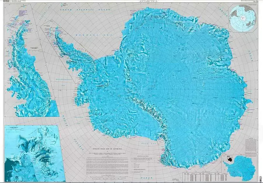
One of the largest wall maps of Antarctica - includes shaded relief as well as contour lines.  Map shows natural features such as mountain peaks, ice streams, ice shelves and glaciers.  Names and locations of year round research stations and what country they are sponsored by also appears on the map.  Also includes latitude and longitude grid and detailed insets of the Antarctic Peninsula and McMurdo Sound.
Price each

Photo Description SKU Units Price Qty cart-icon
Antarctica Large Topographic Wall Map with Research Locations 40" x 56" USGA
$18.00
Add to cart
You Might Also Like:
Photo Description SKU Units Price Qty cart-icon
Antarctica 1934 Antique Map Replica Antique Map of Antarctica 1934
36" x 27"
KROLCANT1934
$36.95
Add to cart
Antarctica Satellite Wall Map National Geographic Antarctica Wall Map by National Geographic
31" x 20"|Paper
NGSANS
$19.95
Add to cart
Antarctica Satellite Wall Map National Geographic Antarctica Wall Map by National Geographic
31" x 20"|Laminated
NGSANS-lam
$29.95
Add to cart
British Arctic Survey Arctic and Antarctica Map Antarctica & The Arctic Map
35" x 29"|1:10,000,000
MAPBASARCTIC
$26.95
Add to cart
Antarctica Travel and Guide Book by Lonely Planet Antarctica Travel Guide Book
Antarctica Travel Guide Book
LPPAntarctica
$28.99
Add to cart
Price $18.00
Quantity
Add to cart
Price $36.95
Quantity
Add to cart
Price $19.95
Quantity
Add to cart
Price $29.95
Quantity
Add to cart
Price $26.95
Quantity
Add to cart
Price $28.99
Quantity
Add to cart
You Previously Viewed:
logo

logo