/1004/site-assets/phone.png)
/1004/site-assets/cart.png)
/1004/images/1199549.jpg)
/1004/images/1194983.jpg "Asia Travel Maps Countries Regions Cities and More!")
/1004/images/1193690.jpg "USGS Topographic Maps")
/1004/images/1194982.jpg "Cruise Ship Inside Passage Alaska Maps")
/1004/images/1199864.jpg)
Learn the basics of compass navigation, finding north, orienting a map, adjusting for declination, and using a compass with a map.
/1004/images/1199837.jpg "Traditional Frame World Map Classic Blue")
Plaque mounting, traditional framing, and foamcore mounting are essential techniques in art display, each serving distinct purposes and catering to different needs.
/1004/images/1198227.jpg)
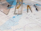
Nautical charts are vital for safe navigation on open waters, providing crucial information about coastlines, water depths, and other navigational aids. These charts contain essential elements such as symbols, abbreviations, and colors that indicate depths and seabed types, which are crucial for creating a navigation plan and guiding boaters on the water.
/1004/images/1199861.jpg)
Learn more about what is the difference between True North, Magnetic North and the proper way to navigate!
/1004/images/1198225.jpg)
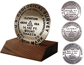
A topographic map is a detailed representation of the Earth's surface and its natural and man-made features.
/1004/images/1198221.jpg)
How do you read and use a map to reach your next destination?
This article covers everything you need to know.
Let's explore!
/1004/site-assets/dateseal.jpg "Serving Seattle since 1950")
/1004/site-assets/creditcards.png)