/1004/site-assets/phone.png)
/1004/site-assets/cart.png)
How To Read a Topographic Map
As covered in another article on How to Read a Map, there are lots of different types of maps available, and each one has its own benefits.
One common type of map is a topographic map, and it may just be the best option for your next adventure.
If you have ever wondered what they are and how they work, this article breaks it down!
What is a Topographic Map?
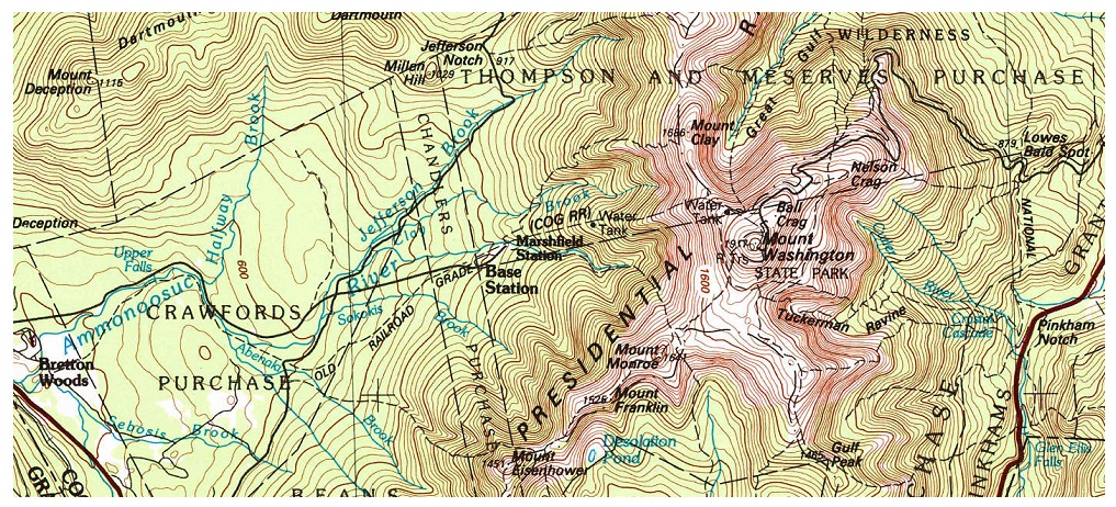
A topographic map is a detailed representation of the Earth's surface and its natural and man-made features. It displays the planet's three-dimensional landscape on a two-dimensional paper map by using contour lines to show the elevation and shape of the terrain. For example, a hill on a map will be indicated with multiple concentric circles around it. Each line connects points of equal elevation, and each elevation is indicated on the map. The lines are essentially slices of land, and the closer those slice lines are, the steeper the land is.
Topographic maps are commonly used by outdoor enthusiasts, such as hikers and backpackers, to explore national parks, national forests, and other public lands. They are also essential tools for map enthusiasts, cartographers, and geologists who study and analyze the Earth's geographical features.
By analyzing the contour lines and map symbols, such as roads and trails indicated in the map's legend (each typically in a different color for easy reference), you can determine the exact elevation of a spot on the map, identify steep slopes or gentle slopes, and plan your route accordingly.
For more information about what a topographical map is and to learn how it works, read on!
How to Read a Topographic Map
Whether you're gearing up for a hiking trip or simply curious about the terrain around you, learning how to read a topographic map can provide you with a wealth of information.
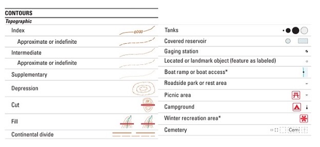
Here are some items shown on a topographic map to help you understand the map better.
Index and Interval Lines
By understanding index and interval lines and interpreting both, you better understand the terrain, identify areas of elevation gain or loss, and navigate the map accurately and confidently.
- Index lines are the thicker, darker contour lines typically labeled with elevation values. These lines help you quickly identify major changes in elevation in the area.
- Interval lines represent the spaces between contour lines and indicate the vertical distance or differences in elevation between contour lines. This distance or elevation amount is usually provided in the legend, often called a contour interval.

Map Scale
The scale printed on the map provides a ratio between the distances on the paper map and the corresponding distances on the ground. It helps you accurately measure distances and make informed decisions to plan your route and estimate travel time.
A common type of scale on a topographic map is a fractional scale, also called a ratio scale.
It indicates a unit of measurement on your map, such as one inch, and how many units that measurement represents in the real world, such as 24,000 inches.
It would be represented as 1:24,000. Converting the 24,000 inches into feet (24,000/12) pencils out to 2,000 feet, so the most common USGS Topo Maps, the 1:24K series, are printed at 1 inch equals 2,000 feet.
For more about other scale types, watch for our upcoming article on map scales!
Colors and Shading
Different colors represent natural and man-made features like rivers, roads, and forests, and types of land, such as forests, mountains, deserts, and cities. Colors can also indicate different elevation levels.
Colors are also indicated on the lines. One of the most important colors on a topographic map is brown, which indicates the contour lines (thick brown lines) and contour intervals (thinner brown lines). Blue represents bodies of water like lakes, rivers, and streams. Green areas represent vegetation and help us differentiate between densely forested areas and open fields.
Map Grids
Map grids help you locate specific points of interest and navigate the terrain accurately. It consists of intersecting lines that form a series of squares or rectangles. The vertical lines on a grid represent the north-south direction, while the horizontal lines represent the east-west direction. These lines are labeled with coordinates in latitude and longitude.
Map Legend
A map legend, also known as a key, is essential for understanding the symbols and colors used on a map. They typically include symbols for features like roads, bodies of water, vegetation, buildings, and tourist points of interest.
A Compass Rose Indicating North
The map will indicate a printed compass indicating the direction north, south, east, and west, called the compass rose. The map will indicate magnetic north as well. In general, understanding which direction north is vital for understanding where you stand in your surroundings. At the same time, knowing the difference between the two norths is crucial for accuracy.
There are two ways to spot north: look at features around you as they relate to the map or use a compass to follow the map's magnetic north. Surprisingly, the two norths are different. The printed north corresponds to the top of the North Pole. In contrast, the magnetic north relates to the Earth's magnetic reading of north, which doesn't sit in the exact location as the top of the Earth's axis.
Declination refers to the angle between true north and magnetic north, and knowing this angle is crucial for using your compass accurately.
To apply declination to a topographic map, you must adjust your compass to compensate for the difference between true north and magnetic north.

How to Use a Topographic Map
Start by finding the north arrow or compass rose on the map to orient the map.
You can then start noting the various terrain features and topographic details from that angle and maintain an understanding of your positioning as you travel.
Before starting your journey, read the contour levels so that you are aware of the terrain and changes in elevation that can affect your timing.
If traveling in a car, make a note of gas stations, rest stops, and other areas to access water, food, and bathrooms on your way.
You can also use contour lines, colors, symbols, roads, and features to determine the best path to your destination.
/1004/site-assets/dateseal.jpg "Serving Seattle since 1950")
/1004/site-assets/creditcards.png)