/1004/site-assets/phone.png)
/1004/site-assets/cart.png)
Role of Maps in Urban Planning
URBAN PLANNING 101: How Humans Design and Regulate Space in Urban Areas
History and Evolution of Maps in Urban Planning
Maps have been used for thousands of years to represent spatial concepts and provide information about the world. Ancient civilizations like the Babylonians and Greeks used maps for navigation and depicted their cities on maps.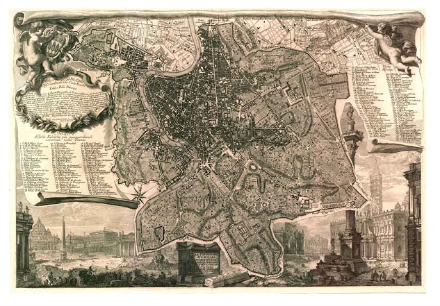
One notable example is the Nolli Map, created by Giovanni Battista Nolli, which was an essential tool for understanding the flow of space within a city. Over time, maps have evolved using technology such as GIS software, satellite imaging, and aerial photography. GIS data helps planners understand cities' current and future needs and make projections for improvement.
As urban planning has become more complex, using maps has become increasingly important. Maps help planners visualize and analyze vast amounts of data, allowing them to make informed decisions about the development of cities.
They visually represent the existing infrastructure, land use patterns, transportation networks, and other spatial data.
By studying these maps, planners can identify areas for development, determine zoning regulations, and make decisions about city growth.
Importance of Maps in Urban Planning
Maps play a crucial role in urban planning by visualizing cities and their components and helping urban planners understand the existing infrastructure, land use patterns, transportation networks, and other spatial data.
By visualizing the city's characteristics, maps aid in identifying areas for development, determining zoning regulations, and making informed decisions about city growth.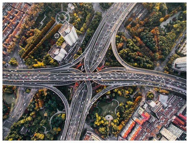
In a city with a growing population, maps can assist planners in identifying areas experiencing high population density and may require additional infrastructure, such as schools or hospitals.
By analyzing the data presented on the maps, planners can make informed decisions about where to allocate resources and how to plan for future growth.
Maps help us understand the impact of proposed developments on the surrounding environment, such as the effects on traffic flow or the preservation of green spaces.
Mapping Techniques and Tools in Urban Planning
Accurate mapping is essential for land use planning and developing new zones.
Town planning consultants use maps to understand traffic flow, housing patterns, economic activities, population density, services, and land value. Various departments and professionals, such as city engineers and land surveyors, use mapping to prevent duplication of efforts and inconsistencies. Base maps serve as a foundation for creating specific maps for different purposes. Updating maps to reflect changes in features and data regularly is crucial.
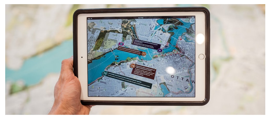
In addition to traditional paper maps, urban planners now have access to advanced mapping techniques and tools.
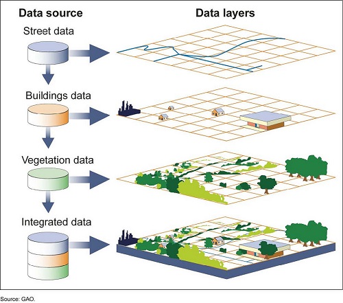
Geographic Information Systems (GIS) are widely used in urban planning due to their ability to analyze and visualize complex spatial data. GIS allows planners to overlay different layers of information, such as land use, transportation, and infrastructure, to gain a comprehensive understanding of the city.
This enables them to identify patterns and trends, make informed decisions, and communicate their plans effectively.
GIS can analyze transportation networks and identify areas that require improvements or new infrastructure. By mapping out existing transportation routes, traffic patterns, and population density, planners can determine where new roads, bridges, or public transportation systems should be built. GIS can also be used to assess the impact of these changes on the environment and ensure that the city's growth is sustainable.
GIS in Urban Planning
GIS (geographic information science and technology) is important in urban planning because it provides robust and constantly updated spatial information. GIS helps urban planners understand the needs of cities, and design to fulfill those needs.
It can be used for analyzing and evaluating land and infrastructure, optimizing building placement, and determining the feasibility of projects.
With GIS technology, urban planners have enhanced visibility and understanding of data, allowing them to monitor fluctuations over time, evaluate proposed projects, and predict their environmental effects. GIS can guide new developments to areas less prone to natural disasters and help revitalize urban areas.
One key advantage of using GIS in urban planning is integrating data from multiple sources. Planners can combine data on demographics, land use, transportation, and environmental factors to create comprehensive maps that provide a holistic city view.
By analyzing this integrated data, planners can identify areas that require improvement, such as neighborhoods with inadequate access to essential services or areas at risk of flooding.
This information can then be used to develop targeted policies and interventions to address these issues.
For example, GIS can be used to analyze the impact of climate change on urban environments. By mapping out areas at risk of flooding or extreme temperatures, planners can identify areas requiring mitigation measures, such as installing green infrastructure or creating cooling centers.
GIS can also be used to assess the effectiveness of these measures over time, allowing planners to make informed decisions about future projects.
Future of Mapping in Urban Planning
Urbanization poses a growing environmental threat as land becomes limited. Mapping software helps manage urban growth and promotes a positive public image of planning departments. Architects and urban designers rely on mapping software to prepare site plans and make policy decisions.
Recent advances in integrating architecture models and visualization make mapping software even more indispensable to urban planning. The potential for further advancements in mapping technology will continue to shape the future of urban planning, contributing to the development of sustainable and livable cities.
The future of mapping in urban planning is likely to be shaped by technological advancements.
As technology evolves, new tools and techniques will emerge, allowing planners to collect, analyze, and visualize data more sophisticatedly. For example, using artificial intelligence and machine learning algorithms can help planners automate the analysis of large datasets, making it easier to identify patterns and trends.
In addition, integrating mapping software with other technologies, such as virtual and augmented reality, holds great potential for urban planning. Planners can use these technologies to create immersive experiences that allow stakeholders to visualize proposed developments more realistically.
This can facilitate better communication and engagement with the community, leading to more inclusive and participatory planning processes.
Overall, the role of maps in urban planning will continue to be vital in shaping the future of cities.
Maps provide planners with a visual representation of the city's characteristics, enabling them to make informed decisions about development, infrastructure, and sustainability.
As technology advances, maps will become even more sophisticated, allowing planners to analyze and visualize data innovatively.
By harnessing the power of mapping technology, urban planners can create sustainable and livable cities that meet the needs of their communities.
/1004/site-assets/dateseal.jpg "Serving Seattle since 1950")
/1004/site-assets/creditcards.png)