/1004/site-assets/phone.png)
/1004/site-assets/cart.png)
The Importance of Nautical Charts
Understanding Nautical Charts
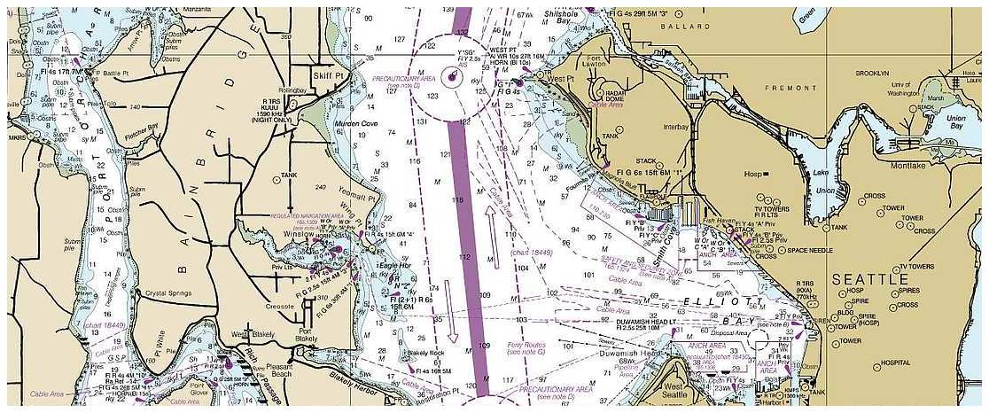
Nautical charts are vital for safe navigation on open waters, providing crucial information about coastlines, water depths, and other navigational aids. These charts contain essential elements such as symbols, abbreviations, and colors that indicate depths and seabed types, which are crucial for creating a navigation plan and guiding boaters on the water. For example, the symbols on nautical charts represent features such as rocks, wrecks, and other underwater hazards, alerting mariners to potential dangers in specific areas. Understanding these symbols is essential for safe navigation.
Additionally, nautical charts come in various scales and measurements, encompassing small-scale and large-scale charts, with details about depth, dangers, aids to navigation, scale, distance, and chart notes. Mariners need to understand the differences between small-scale and large-scale charts and how to interpret the information presented on each type of chart. For instance, small-scale charts cover a larger area but provide less detailed information, while large-scale charts offer more detailed information over a smaller area. This knowledge is crucial for boaters to select the most appropriate chart for their specific navigation needs, ensuring access to the necessary details for a safe and successful voyage. Understanding these elements is fundamental for mariners to navigate safely and effectively.
As mariners delve into the world of nautical charts, it becomes evident that these tools are not just maps but comprehensive guides that hold the key to safe and successful navigation. By grasping the significance of the symbols, abbreviations, scales, and measurements on nautical charts, boaters can enhance their understanding of the open waters, enabling them to navigate confidently and precisely. For individuals seeking high-quality nautical charts to aid their navigation endeavors, Metsker Maps offers a wide range of reliable products tailored to various navigation requirements, providing boaters with the tools they need for safe and effective navigation.
Interpreting Nautical Chart Symbols and Abbreviations
To effectively interpret nautical chart symbols and abbreviations, it is essential to understand their significance for safe navigation.
For instance, depth, soundings, and isobaths are crucial elements on nautical charts as they provide valuable information about water depth and elevation. This information is vital for mariners, enabling them to navigate safely and avoid potential hazards. Nautical charts are essential for navigation on the open waters. They contain symbols, abbreviations, and colors that indicate depths and types of seabed. Depth, soundings, and isobaths are essential for navigation and display of water depth and elevation. Letters on the chart indicate the type and quality of the seabed, as well as potential dangers.
Nautical charts are used to create a navigation plan and guide boaters on the water. They are also helpful for navigating in changing weather conditions and high winds. The National Boating Safety School offers resources to help refine knowledge of nautical charts for recreational and commercial navigation. For example, understanding the difference between soundings and isobaths can help boaters identify shallow areas and underwater hazards, ensuring a secure passage through navigable waters.
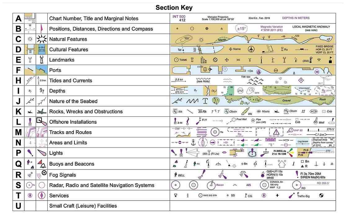
In addition to depth-related symbols, letters on the chart indicate the type and quality of the seabed, as well as potential dangers. For instance, the letter "M" on a nautical chart might tell mud, while "R" might represent rock. This information is indispensable for safe navigation, allowing mariners to assess the seabed conditions and make informed decisions about anchoring or avoiding certain areas.
Furthermore, the compass rose, commonly found on nautical charts, aids in determining true and magnetic north. This is crucial for accurate navigation, especially when considering variations in magnetic declination. By understanding and applying these symbols and abbreviations, mariners can confidently navigate open waters, ensuring the safety of their vessels and crew.
Navigational Aids and Landmarks on Nautical Charts
In addition to depicting navigational aids like buoys, beacons, and lights, nautical charts are crucial in providing essential information for safe navigation on open waters. For instance, the symbols used on nautical charts to represent these aids are vital for guiding boaters and mariners, helping them identify each navigational aid's specific purpose and function. This information assists in plotting a safe and efficient course while avoiding potential hazards or obstacles along the way.
Moreover, nautical charts illustrate depth contour lines, submerged objects, anchorages, channels, lighthouses, and buoys, offering mariners a comprehensive overview of the surrounding environment. For example, mariners can confidently navigate through waterways by understanding the depth contour lines and the location of submerged objects, knowing the potential hazards and safe passages. This detailed information empowers boaters to make informed decisions, ensuring safe and reliable navigation, especially in unfamiliar or challenging waters.

Using Nautical Charts for Safe Navigation
When navigating in challenging conditions, such as changing weather and high winds, boaters can rely on nautical charts to ensure safe passage. Understanding how to interpret the information on these charts is essential for effective and secure navigation.
For example, nautical charts provide critical details about coastlines, water depths, and various navigational aids, allowing boaters to plan their routes and avoid potential hazards. Using nautical charts, mariners can make informed decisions and navigate confidently, even in adverse conditions.
In addition, despite the prevalence of GPS chart plotters, the importance of comprehending traditional nautical charts and navigation techniques must be considered. These charts remain relevant and continue to play a vital role in ensuring safe travels on the water.
For boaters seeking reliable and high-quality nautical charts, companies like Metsker Maps offer a wide range of products designed to enhance navigation for both recreational and commercial purposes. By incorporating these charts into their navigation planning, boaters can elevate their safety and confidence while on the water, making their journeys more enjoyable and secure.
Resources for Refining Knowledge of Nautical Charts
Regarding refining knowledge of nautical chart symbols and abbreviations, mariners can find valuable resources to enhance their navigation skills. The National Boating Safety School is a reputable organization that offers comprehensive recreational and commercial navigation materials, covering essential topics related to nautical chart interpretation and safe navigation practices. These resources can provide in-depth insights into understanding the significance of various symbols, abbreviations, and colors found on nautical charts, empowering mariners with the knowledge needed for confident navigation on open waters.

In addition to the National Boating Safety School, boaters can also benefit from membership with BoatUS, which offers a range of valuable resources to enhance navigation knowledge and skills. Membership perks include a subscription to BoatUS Magazine, providing expert insights, tips, and updates on nautical chart usage, navigational aids, and safe boating practices.
Moreover, members can access discounts and exclusive materials that contribute to a deeper understanding of nautical charts, further refining their ability to interpret chart symbols and abbreviations for safe and reliable navigation. By leveraging these resources, mariners can solidify their expertise in nautical chart interpretation, ultimately ensuring safer voyages on the water.
Conclusion
Understanding nautical charts is indispensable for safe navigation, as they provide vital information for mariners to navigate open waters securely. Nautical charts are essential for interpreting depth and contour lines, understanding navigational aids and landmarks, and refining knowledge of chart symbols and abbreviations.
For example, depth soundings and isobaths on nautical charts indicate water depth and elevation, while symbols and abbreviations depict crucial information about coastlines, water depths, and other navigational aids. Additionally, navigational aids such as buoys, beacons, and lights are shown on charts with symbols indicating their purpose, providing critical guidance for boaters on the water.
/1004/site-assets/dateseal.jpg "Serving Seattle since 1950")
/1004/site-assets/creditcards.png)