/1004/site-assets/phone.png)
/1004/site-assets/cart.png)
Oregon 1:24K Topo Maps
Find the general area for your 7.5' USGS Oregon topographic map, then click on the section title below...
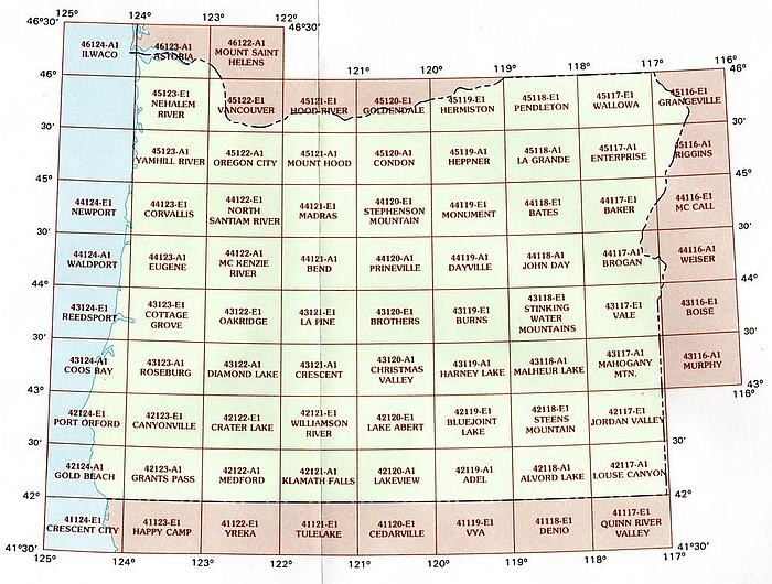
For a list of each area and their titles, click on the images below!
Most map aficionados are familiar with the USGS series, but for those of you who don't know much about them, we're here to help!
These maps, also known as the "7.5 minute maps" are topographical sectionals used by hikers, fishers, hunters and outdoor adventurers.
With the smallest scale available, these are the most detailed maps of Oregon from USGS and are the clearest prints using contour lines.
Hills, Depressions, Cliffs, Plateaus, Roads, Trails, Power Lines and Shelters are a few examples of what is clearly marked on these maps.
The 7.5 minute series measures approximately 22" x 27" and each map area covers about a 6 by 9 mile area.
/1004/images/1199260.jpg "Adel OR Area USGS 1:24K Topo Map Index")
/1004/images/1199262.jpg "Alvord Lake OR Area USGS 1:24K Topo Map Index")
/1004/images/1199170.jpg "Astoria (and Ilwaco) OR Area USGS 1:24K Topo Map Index")
/1004/images/1199193.jpg "Baker (and McCall) OR Area USGS 1:24K Topo Map Index")
/1004/images/1199189.jpg "Bates OR Area USGS 1:24K Topo Map Index")
/1004/images/1199197.jpg "Bend OR Area USGS 1:24K Topo Map Index")
/1004/images/1199247.jpg "Bluejoint Lake OR Area USGS 1:24K Topo Map Index")
/1004/images/1199207.jpg "Brogan (and Weiser) OR Area USGS 1:24K Topo Map Index")
/1004/images/1199220.jpg "Brothers OR Area USGS 1:24K Topo Map Index")
/1004/images/1199225.jpg "Burns OR Area USGS 1:24K Topo Map Index")
/1004/images/1199266.jpg "Canyonville OR Area USGS 1:24K Topo Map Index")
/1004/images/1199230.jpg "Christmas Valley OR Area USGS 1:24K Topo Map Index")
/1004/images/1199157.jpg "Condon OR Area USGS 1:24K Topo Map Index")
/1004/images/1199216.jpg "Coos Bay OR Area USGS 1:24K Topo Map Index")
/1004/images/1199181.jpg "Corvallis (& Newport) OR Area USGS 1:24K Topo Map Index")
/1004/images/1199211.jpg "Cottage Grove OR Area USGS 1:24K Topo Map Index")
/1004/images/1199242.jpg "Crater Lake OR Area USGS 1:24K Topo Map Index")
/1004/images/1199232.jpg "Crescent OR Area USGS 1:24K Topo Map Index")
/1004/images/1199203.jpg "Dayville OR Area USGS 1:24K Topo Map Index")
/1004/images/1199234.jpg "Diamond Lake OR Area USGS 1:24K Topo Map Index")
/1004/images/1199162.jpg "Enterprise OR Area USGS 1:24K Topo Map Index")
/1004/images/1199195.jpg "Eugene (and Waldport) OR Area USGS 1:24K Topo Map Index")
/1004/images/1199268.jpg "Gold Beach OR Area USGS 1:24K Topo Map Index")
/1004/images/1199135.jpg "Goldendale OR Area USGS 1:24K Topo Map Index")
/1004/images/1199142.jpg "Grangeville OR Area USGS 1:24K Topo Map Index")
/1004/images/1199270.jpg "Grants Pass OR Area USGS 1:24K Topo Map Index")
/1004/images/1199235.jpg "Harney Lake OR Area USGS 1:24K Topo Map Index")
/1004/images/1199159.jpg "Heppner OR Area USGS 1:24K Topo Map Index")
/1004/images/1199138.jpg "Hermiston OR Area USGS 1:24K Topo Map Index")
/1004/images/1199139.jpg "Hood River OR Area USGS 1:24K Topo Map Index")
/1004/images/1199206.jpg "John Day OR Area USGS 1:24K Topo Map Index")
/1004/images/1199250.jpg "Jordan Valley OR Area USGS 1:24K Topo Map Index")
/1004/images/1199254.jpg "Klamath Falls OR Area USGS 1:24K Topo Map Index")
/1004/images/1199161.jpg "La Grande OR Area USGS 1:24K Topo Map Index")
/1004/images/1199222.jpg "La Pine OR Area USGS 1:24K Topo Map Index")
/1004/images/1199244.jpg "Lake Abert OR Area USGS 1:24K Topo Map Index")
/1004/images/1199256.jpg "Lakeview OR Area USGS 1:24K Topo Map Index")
/1004/images/1199264.jpg "Louse Canyon OR Area USGS 1:24K Topo Map Index")
/1004/images/1199183.jpg "Madras OR Area USGS 1:24K Topo Map Index")
/1004/images/1199238.jpg "Mahogany Mountain OR Area USGS 1:24K Topo Map Index")
/1004/site-assets/dateseal.jpg "Serving Seattle since 1950")
/1004/site-assets/creditcards.png)